


BC HighwayCams - Highway 19
Please note all BC HwyCams use Pacific Time Zone (PT).
Attention motorists:
Spring weather can make highway conditions in B.C. unpredictable, particularly through high mountain passes. Please be prepared and be aware that winter tires and chains may still be needed.
We reserve the right to restrict travel at any time of the year depending on road conditions.
Click for more information
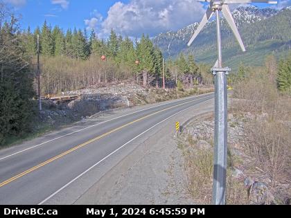 |
Tsitika
Highway 19 about 101 km north of Campbell River and about 27 km south of Woss near Tsitika, looking southeast. (elevation: 421 metres) |
||
|
|||
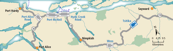
 Port Hardy - N Highway 19 at Douglas Street, looking north along Highway 19 (Bear Cove Highway). |  Port Hardy - W Highway 19 at Douglas Street, looking west along Douglas Street. |  Port Hardy - E Highway 19 at Douglas Street, looking east along Highway 19. |  Hwy 19 at Port Alice Road Highway 19 at Highway 30 (Port Alice Road) between Port Hardy and Port McNeill, looking south. |
 Port McNeill - W Highway 19 at Campbell Way in Port McNeill, looking west. |  Port McNeill - E Highway 19 at Campbell Way in Port McNeill, looking east. |  Hyde Creek Road - W Highway 19 about 4.5 km south of Port McNeill near Hyde Creek Road, looking west. |  Hyde Creek Road - E Highway 19 about 4.5 km south of Port McNeill near Hyde Creek Road, looking east. |
 Woss Highway 19 about 75 km southeast of Port McNeill and 128 km north of Campbell River, looking east. |  Tsitika Highway 19 about 101 km north of Campbell River and about 27 km south of Woss near Tsitika, looking southeast. |  Roberts Lake Highway 19 about 31 km north of Campbell River, looking north. |  Menzies Hill - N Highway 19 about 7 km southeast of Roberts Lake and 24 km north of Campbell River at Menzies Hill, looking north. |
 Menzies Hill - S Highway 19 about 7 km southeast of Roberts Lake and 24 km north of Campbell River at Menzies Hill, looking south. |  Duncan Bay - N Highway 19 north of Campbell River between Orange Point Road and Duncan Bay Road, looking north. |  Duncan Bay - S Highway 19 north of Campbell River between Orange Point Road and Duncan Bay Road, looking south. |  Campbell River - N Highway 19 about 2.5 km south of Campbell River at Willis Road, looking north. |
 Campbell River - W Highway 19 about 2.5 km south of Campbell River at Willis Road, looking west. |  Campbell River - E Highway 19 about 2.5 km south of Campbell River at Willis Road, looking east. |  Campbell River - S Highway 19 about 2.5 km south of Campbell River at Willis Road, looking south. |  Black Creek Highway 19 about 25 km north of Courtenay at Hamm Road, looking north. |
 Piercy Road - N Hwy 19 at Piercy Road, looking north. |  Piercy Road - S Highway 19 at Piercy Road, looking south. |  Buckley Bay Road Highway 19 near the Buckley Bay Road Interchange, looking north. |  Cook Creek Road Highway 19 about 29 km north of Parksville at Cook Creek Road, looking north. |
 Horne Lake Road - N Highway 19 at Horne Lake Road, looking north. |  Horne Lake Road - W Highway 19 at Horne Lake Road, looking west. |  Horne Lake Road - E Highway 19 at Horne Lake Road, looking east. |  Horne Lake Road - S Highway 19 at Horne Lake Road, looking south. |
 Qualicum Interchange - W Highway 19 south of Qualicum Interchange at Highway 4, looking west. |  Qualicum Interchange - E Highway 19 south of Qualicum Interchange at Highway 4, looking east. |  Nanoose Bay - N Highway 19 at Northwest Bay Road near Nanoose Bay, looking north. |  Nanoose Bay - E Highway 19 at Northwest Bay Road near Nanoose Bay, looking east. |
 Nanoose Bay - S Highway 19 at Northwest Bay Road near Nanoose Bay, looking south. |  Nanoose Rest Area - N Highway 19 at the Nanoose Rest Area, looking north. |  Nanoose Rest Area - S Highway 19 at the Nanoose Rest Area, looking south. |  Lantzville - N Highway 19 near McKercher Road in Lantzville, looking northbound. |
 Lantzville - S Highway 19 near McKercher Road in Lantzville, looking southbound. |  Aulds Road - N Highway 19 at Aulds Road in Nanaimo, looking north. |  Aulds Road - W Highway 19 at Aulds Road in Nanaimo, looking west. |  Aulds Road - E Highway 19, at Aulds Road in Nanaimo, looking east. |
 Aulds Road - S Highway 19 at Aulds Road in Nanaimo, looking south. |  Northfield Road - N Highway 19 at Northfield Road in Nanaimo, looking north. |  Northfield Road - W Highway 19 at Northfield Road in Nanaimo, looking west. |  Northfield Road - E Highway 19 at Northfield Road in Nanaimo, looking east |
 Northfield Road - S Highway 19 at Northfield Road in Nanaimo, looking south. |  Nanaimo Parkway Highway 19 at College Drive, looking north. |
||
