


BC HighwayCams - Highway 3
Please note all BC HwyCams use Pacific Time Zone (PT).
Attention motorists:
Spring weather can make highway conditions in B.C. unpredictable, particularly through high mountain passes. Please be prepared and be aware that winter tires and chains may still be needed.
We reserve the right to restrict travel at any time of the year depending on road conditions.
Click for more information
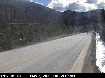 |
Allison Pass - E
Hwy 3 at Allison Pass, 10 km west of Manning Park resort area, looking east. (elevation: 1343 metres) |
||
|
|||
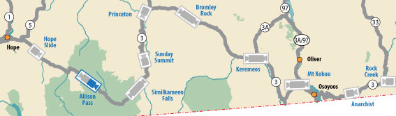
 Hwy 3 at Highway 3/5 Junction Highway 3 at Highway 3/5 junction, looking east. |  Hope Slide Highway 3 at the Hope Slide pullout, looking east. |  Allison Pass - W Highway 3 about 10 km west of Manning Park resort area at Allison Pass, looking west. |  Allison Pass - E Hwy 3 at Allison Pass, 10 km west of Manning Park resort area, looking east. |
 Similkameen Falls - W Highway 3 about 6 kms east of Eastgate near Similkameen Falls, looking west. |  Similkameen Falls - E Highway 3 about 6 kms east of Eastgate near Similkameen Falls, looking east. |  Sunday Summit - N Highway 3 about 32 km south of Princeton, looking north. |  Sunday Summit - S Highway 3 about 32 km south of Princeton, looking south. |
 Princeton Highway 3 at Frontage Road on the west side of Princeton, looking south. |  Bromley Rock - W Highway 3 about 1.4 km east of Bromley Rock Provincial Park, looking west. |  Bromley Rock - E Highway 3 about 1.4 km east of Bromley Rock Provincial Park, looking east. |  Keremeos - W Highway 3 at Keremeos Bypass Road, looking west. |
 Keremeos - E Highway 3 at Keremeos Bypass Road, looking east. |  Mount Kobau - W Highway 3 next to Conifryd Lake, looking west. |  Mount Kobau - E Highway 3 next to Conifryd Lake, looking east. |  Anarchist Highway 3 about 9 km west of the Anarchist Summit, looking east. |
 Rock Creek Highway 3 at Highway 33 junction in Rock Creek, looking northwest. |  Midway - W Highway 3 at Florence Street in Midway, looking west. |  Midway - E Highway 3 at Florence Street in Midway, looking east. |  Midway - S Highway 3 at Florence Street in Midway, looking south. |
 Eholt Summit Highway 3 about 16 km northeast of Greenwood at Wilgress Rest Area near Eholt Summit, looking westbound. |  Christina Lake - NW Highway 3 at East Lake Drive on east side of Christina Lake, looking northwest. |  Christina Lake - SE Highway 3 at East Lake Drive on east side of Christina Lake, looking southeast. |  Paulson Summit Highway 3 near the Paulson Summit, looking west. |
 Castlegar - W Highway 3 at 14 Avenue in Castlegar, looking west. |  Castlegar - E Highway 3 at 14 Avenue in Castlegar, looking east. |  Bombi Pass Highway 3 about 22 km south-east of Castlegar at the Bombi Summit, looking west. |  Meadows Junction Highway 3 at Highway 3B junction looking westbound. |
 Salmo Highway 3 at Highway 6 junction, looking west on Highway 3. |  Kootenay Pass Highway 3 at Salmo Creston Highway Summit, looking east. |  Creston - N Highway 3 and Highway 3A junction in Creston, looking north. |  Creston - W Highway 3 and Highway 3A junction in Creston, looking west. |
 Creston - S Highway 3 and Highway 3A junction in Creston, looking south. |  Leadville Road Highway 3 about 18 km east of Creston in Kitchener, looking east. |  Goatfell - W Highway 3 about 9 km northwest of Yahk near Goatfell, looking west. |  Goatfell - E Highway 3 about 9 km northwest of Yahk near Goatfell, looking east. |
 Yahk Highway 3 at Highway 95 junction by the Yahk Weigh Scale, looking northeast. |  Irishman - N Highway 3 about 21 km southwest of Moyie, looking north. |  Irishman - S Highway 3 about 21 km southwest of Moyie, looking south. |  Moyie Lake Highway 3 near the south end of Moyie Lake, looking north. |
 Cranbrook Highway 3/95 at 9 Avenue in Cranbrook, looking northeast. |  Steamboat- NW Highway 3/93 near Ha Ha Creek Road, looking northwest. |  Steamboat - SE Highway 3/93 near Ha Ha Creek Road, looking southeast. |  Elko - W Highway 3 about 1 km west of Elko at Highway 93 junction, looking west. |
 Elko - E Highway 3 about 1 km west of Elko at Highway 93 junction, looking east. |  Elko - S Highway 3 about 1 km west of Elko at Highway 93 junction, looking south. |  Morrissey Highway 3 about 10 km south of Fernie at Morrissey Junction, looking north. |  Hosmer Highway 3 about 12 km north of Fernie in Hosmer, looking north. |
 Sparwood Highway 3 about 2 km west of the Alberta border at Sparwood Weigh Scale, looking southeast. |
|||
