

BC HighwayCams - Highway 3
Please note all BC HwyCams use Pacific Time Zone (PT).
Attention motorists:
Fall weather can make highway conditions in B.C. unpredictable, particularly through high mountain passes. Winter tires or chains are required on most routes in British Columbia from October 1 to April 30.

Click for more information
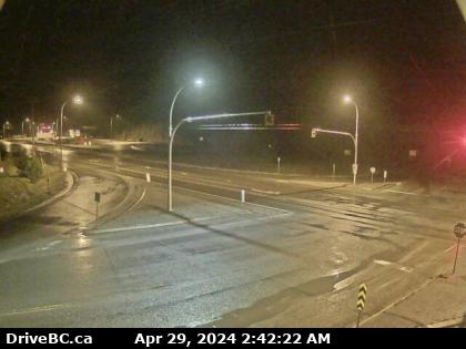 |
Yahk
Highway 3 at Highway 95 junction by the Yahk Weigh Scale, looking northeast. (elevation: 854 metres) |
||
Weather Forecast (from Environment Canada)All weather stations (current weather) for this region (map) |
|||
|
|||
 Hwy 3 at Hwy3/5 Jct Highway 3 at Highway 3/5 junction, looking east. |  Hope Slide Highway 3 at the Hope Slide pullout, looking east. |  Allison Pass - W Highway 3 about 10 km west of Manning Park resort area at Allison Pass, looking west. |  Allison Pass - E Hwy 3 at Allison Pass, 10 km west of Manning Park resort area, looking east. |
Image Temporarily Unavailable. Similkameen Falls - W Highway 3 about 6 kms east of Eastgate near Similkameen Falls, looking west. | Image Temporarily Unavailable. Similkameen Falls - E Highway 3 about 6 kms east of Eastgate near Similkameen Falls, looking east. |  Sunday Summit Highway 3 about 32 km south of Princeton, looking north. |  Princeton Highway 3 at Frontage Road on the west side of Princeton, looking south. |
 Bromley Rock - W Highway 3 about 1.4 km east of Bromley Rock Provincial Park, looking west. |  Bromley Rock - E Highway 3 about 1.4 km east of Bromley Rock Provincial Park, looking east. |  Keremeos - W Highway 3 at Keremeos Bypass Road, looking west. |  Keremeos - E Highway 3 at Keremeos Bypass Road, looking east. |
 Mount Kobau - W Highway 3 next to Conifryd Lake, looking west. |  Mount Kobau - E Highway 3 next to Conifryd Lake, looking east. |  Anarchist Highway 3 about 9 km west of the Anarchist Summit, looking east. |  Rock Creek Highway 3 at Highway 33 junction in Rock Creek, looking northwest. |
 Midway - W Highway 3 at Florence Street in Midway, looking west. |  Midway - E Highway 3 at Florence Street in Midway, looking east. |  Midway - S Highway 3 at Florence Street in Midway, looking south. |  Eholt Summit Highway 3 about 16 km northeast of Greenwood at Wilgress Rest Area near Eholt Summit, looking westbound. |
 Christina Lake Highway 3 at East Lake Drive on east side of Christina Lake, looking northwest. |  Paulson Summit Highway 3 near the Paulson Summit, looking west. |  Castlegar Highway 3 at 14 Avenue in Castlegar, looking east. | Image Temporarily Unavailable. Bombi Pass Highway 3 about 22 km south-east of Castlegar at the Bombi Summit, looking west. |
 Meadows Junction Highway 3 at Highway 3B junction looking westbound. |  Salmo Highway 3 at Highway 6 junction, looking west on Highway 3. |  Kootenay Pass Highway 3 at Salmo Creston Highway Summit, looking east. |  Creston Highway 3 and Highway 3A junction in Creston, looking southeast. |
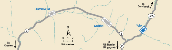
 Leadville Road Highway 3 about 18 km east of Creston in Kitchener, looking east. |  Goatfell - W Highway 3 about 9 km northwest of Yahk near Goatfell, looking west. |  Goatfell - E Highway 3 about 9 km northwest of Yahk near Goatfell, looking east. |  Yahk Highway 3 at Highway 95 junction by the Yahk Weigh Scale, looking northeast. |
Image Temporarily Unavailable. Irishman - N Highway 3 about 21 km southwest of Moyie, looking north. | Image Temporarily Unavailable. Irishman - S Highway 3 about 21 km southwest of Moyie, looking south. |  Moyie Lake Highway 3 near the south end of Moyie Lake, looking north. |  Cranbrook Highway 3/95 at 9 Avenue in Cranbrook, looking northeast. |
 Steamboat- NW Highway 3/93 near Ha Ha Creek Road, looking northwest. |  Steamboat - SE Highway 3/93 near Ha Ha Creek Road, looking southeast. |  Elko - W Highway 3 about 1 km west of Elko at Highway 93 junction, looking west. |  Elko - E Highway 3 about 1 km west of Elko at Highway 93 junction, looking east. |
 Elko - S Highway 3 about 1 km west of Elko at Highway 93 junction, looking south. |  Morrissey Highway 3 about 10 km south of Fernie at Morrissey Junction, looking north. |  Hosmer Highway 3 about 12 km north of Fernie in Hosmer, looking north. |  Sparwood Highway 3 about 2 km west of the Alberta border at Sparwood Weigh Scale, looking southeast. |
