


BC HighwayCams - Highway 29
Please note all BC HwyCams use Pacific Time Zone (PT).
Attention motorists:
Spring weather can make highway conditions in B.C. unpredictable, particularly through high mountain passes. Please be prepared and be aware that winter tires and chains may still be needed.
We reserve the right to restrict travel at any time of the year depending on road conditions.
Click for more information
 |
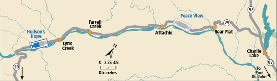
Hudson's Hope - SW
Highway 29 about 1.5 km north of Hudson's Hope at Powell Road, looking southwest. (elevation: 527 metres) |
||
|
|||
 Hudson's Hope - NE Highway 29 about 1.5 km north of Hudson's Hope at Powell Road, looking northeast. |  Hudson's Hope - SW Highway 29 about 1.5 km north of Hudson's Hope at Powell Road, looking southwest. |  Tumbler Ridge Highway 29 at Highway 52 junction, looking westbound on Highway 29. |  Peace View Rest Area - NE Highway 29 about 29 km west of Fort St. John, looking northeast. |
 Peace View Rest Area - SW Highway 29 about 29 km west of Fort St. John, looking southwest. |
|||
