


BC HighwayCams - Highway 23
Please note all BC HwyCams use Pacific Time Zone (PT).
Attention motorists:
Spring weather can make highway conditions in B.C. unpredictable, particularly through high mountain passes. Please be prepared and be aware that winter tires and chains may still be needed.
We reserve the right to restrict travel at any time of the year depending on road conditions.
Click for more information
 |
|
|||||||
|
||||||||
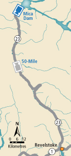
 Mica Dam - N Highway 23 at Mica Dam about 152 km north of Revelstoke, looking north. |  Mica Dam - S Highway 23 at Mica Dam about 152 km north of Revelstoke, looking south. |  50-Mile Highway 23 about 90 km north of Revelstoke, looking north. |  Blanket Creek - N Highway 23 about 30 km south of Revelstoke and 22 km north of Shelter Bay Ferry, looking north. | |||||
 Blanket Creek - S Highway 23 about 30 km south of Revelstoke and 22 km north of Shelter Bay Ferry, looking south. |  Shelter Bay - End Highway 23 near the Upper Arrow Lake ferry landing at Shelter Bay, end of queue, looking north. |  Shelter Bay - Lineup Highway 23 near the Upper Arrow Lake ferry landing at Shelter Bay, looking north at lineup. |  Shelter Bay - Ferry Ramp Highway 23 near the Upper Arrow Lake ferry landing at Shelter Bay, looking south at terminal ramp. | |||||
 Galena Bay Landing - End Highway 23 near the Upper Arrow Lake ferry landing at Galena Bay, looking at end of lineup. |  Galena Bay Landing - Front Highway 23 near the Upper Arrow Lake ferry landing at Galena Bay, looking at front of lineup. |  Galena Bay Landing - Lineup Highway 23, at the bottom of the Upper Arrow Lake ferry landing at Galena Bay, looking at lineup. |  Galena Bay Landing - Ferry Ramp Highway 23, at the bottom of the Upper Arrow Lake ferry landing at Galena Bay, looking at ferry boarding. | |||||
