


BC HighwayCams - Highway 1 (Trans Canada Highway)
Please note all BC HwyCams use Pacific Time Zone (PT).
Attention motorists:
Spring weather can make highway conditions in B.C. unpredictable, particularly through high mountain passes. Please be prepared and be aware that winter tires and chains may still be needed.
We reserve the right to restrict travel at any time of the year depending on road conditions.
Click for more information
 |
Quartz Creek - W
Highway 1 about 40 km west of Golden near the Quartz Creek bridge, looking west. (elevation: 1080 metres) |
||
|
|||
 Yale - N Highway 1 at Victoria Street in Yale, looking northbound. |  Yale - S Highway 1 at Victoria Street in Yale, looking southbound. |  Alexandra Bridge - N Highway 1 at Alexandra Bridge, looking north. |  Alexandra Bridge - S Highway 1 at Alexandra Bridge, looking south. |
 Hells Gate - N Highway 1 about 3.5 km south of Hells Gate at Bradley Hill, looking north. |  Hells Gate - S Highway 1 about 3.5 km south of Hells Gate at Bradley Hill, looking south. |  Boston Bar - N Highway 1 about 12 km north of Boston Bar at Kahmoose Road in Boothroyd, looking north. |  Boston Bar - S Highway 1 about 12 km north of Boston Bar at Kahmoose Road in Boothroyd, looking south. |
 Jackass Mountain - N Highway 1 between Boston Bar and Lytton at Jackass Mountain summit by CəX̣ʷ Cixʷ (Check-Chow) Bridge, looking north. |  Jackass Mountain - S Highway 1 between Boston Bar and Lytton at Jackass Mountain summit by CəX̣ʷ Cixʷ (Check-Chow) Bridge, looking south. |  Gladwin - W Highway 1 about 6 km east of Lytton Airport, looking west. |  Gladwin - E Highway 1 about 6 km east of Lytton Airport, looking east. |
 Spences Bridge Highway 1 at the north end of Spences Bridge on the west side of the Thompson River, looking north. |  Cache Creek Highway 1 at Collins Road, looking east on Highway 1/97. |  Savona Highway 1 at Holloway Drive near Savona, looking west. |  Dufferin - W Highway 1 about 9 km west of Kamloops, looking west. |
 Dufferin - E Highway 1 about 9 km west of Kamloops, looking east. |  Kamloops - W Highway 1 at Peterson Creek bridge in Kamloops, looking west. |  Kamloops - E Highway 1 at Peterson Creek bridge in Kamloops, looking east. |  Miners Bluff - W Highway 1 between Monte Creek and Pritchard, looking west. |
 Miners Bluff - E Highway 1 between Monte Creek and Pritchard, looking east. |  Squilax - W Highway 1 east of Squilax Bridge, looking west. |  Squilax - E Highway 1 east of Squilax Bridge, looking east. |  Sorrento - Blind Bay Highway 1 at Highland Drive east of Sorrento at the Blind Bay turn off, looking southeast. |
 Salmon Arm - N Highway 1 at 30 Street SW in Salmon Arm, looking north. |  Salmon Arm - W Highway 1 at 30 Street SW in Salmon Arm, looking west. |  Salmon Arm - E Highway 1 at 30 Street SW in Salmon Arm, looking east. |  Salmon Arm - S Highway 1 at 30 Street SW in Salmon Arm, looking south. |
 Annis Pit - W Highway 1 about 8 km southwest of Sicamous at Annis Pit, looking west. |  Annis Pit - E Highway 1 about 8 km southwest of Sicamous at Annis Pit, looking east. |  Sicamous - W Highway 1 east of Sicamous at Cambie Road/Solsqua Road, looking west. |  Sicamous - E Highway 1 east of Sicamous at Cambie Road/Solsqua Road, looking east. |
 Perry River - W Highway 1 about 30 km east of Sicamous near Perry River Bridge, looking west. |  Perry River - E Highway 1 about 30 km east of Sicamous near Perry River Bridge, looking east. |  Eagle River - W Highway 1 about 33 km west of Revelstoke, looking west. |  Eagle River - E Highway 1 about 33 km west of Revelstoke, looking east. |
 Griffin Lake - W Highway 1 about 27 km west of Revelstoke by Griffin Lake, looking west. |  Griffin Lake - E Highway 1 about 27 km west of Revelstoke by Griffin Lake, looking east. |  Three Valley Gap - W Highway 1 about 20 km west of Revelstoke near Three Valley Gap, looking west. |  Three Valley Gap - E Highway 1 about 20 km west of Revelstoke near Three Valley Gap, looking east. |
 Clanwilliam Railway Overpass - W Highway 1 about 14 km west of Revelstoke, looking west. |  Clanwilliam Railway Overpass - E Highway 1 about 14 km west of Revelstoke, looking east. |  Boulder Hill - W Highway 1 about 7 km west of Revelstoke, looking west. |  Boulder Hill - E Highway 1 about 7 km west of Revelstoke, looking east. |
 One-Mile Hill - W Highway 1 about 4 km west of Revelstoke, looking west. |  One-Mile Hill - E Highway 1 about 4 km west of Revelstoke, looking east. |  Hwy 1 at Hwy 23 - N Highway 1 at Highway 23 in Revelstoke, looking north to Westside Road. |  Hwy 1 at Hwy 23 - W Highway 1 at Highway 23 in Revelstoke, looking west. |
 Hwy 1 at Hwy 23 - E Highway 1 at Highway 23 in Revelstoke, looking east. |  Hwy 1 at Hwy 23 - S Highway 1 at Highway 23 in Revelstoke, looking south to Highway 23. |  Revelstoke Highway 1 at east end of Columbia River Bridge in Revelstoke, looking eastbound. |  Albert Canyon Highway 1 about 30 km east of Revelstoke, looking east. |
Image Temporarily Unavailable. Jack McDonald Snowshed Highway 1 about 46 km east of Revelstoke, looking east. |  Rogers Pass Highway 1 about 72 km east of Revelstoke at Rogers Pass in Glacier National Park, looking east. |  Quartz Creek - W Highway 1 about 40 km west of Golden near the Quartz Creek bridge, looking west. |  Quartz Creek - E Highway 1 about 40 km west of Golden on the Quartz Creek bridge, looking east. |
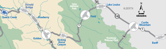
 Donald Bridge - W Highway 1 about 28 km north of Golden at Donald Bridge, looking west. |  Donald Bridge - E Highway 1 about 28 km north of Golden at Donald Bridge, looking east. |  Blaeberry - NW Highway 1 near Blaeberry River Bridge, looking northwest. |  Blaeberry - SE Highway 1 near Blaeberry River Bridge, looking southeast. |
 Golden northbound Highway 1 at Highway 95 interchange, looking northbound along Highway 1. |  Golden eastbound Highway 1 at Highway 95 interchange, looking eastbound along Highway 1. |  Golden southbound Highway 1 at Highway 95 interchange, looking southbound along Highway 95. |  Kicking Horse Canyon Highway 1 at 10 Mile Brake Check in Kicking Horse Canyon, looking east. |
 Field - SW Highway 1 about 16 km west of BC/Alberta border at Field Access Road, looking southwest. |  Field - NE Highway 1 about 16 km west of BC/Alberta border at Field Access Road, looking northeast |  Field - SE Highway 1 about 16 km west of BC/Alberta border at Field Access Road, looking southeast. |  Lake Louise - W Highway 1 west of Lake Louise Overpass in Alberta, looking west. |
 Lake Louise - E Highway 1 west of Lake Louise Overpass in Alberta, looking east. |  Castle Mountain - W Highway 1 at Highway 93S junction, looking west. |  Castle Mountain - E Highway 1 at Highway 93S junction, looking east. |  Castle Mountain - S Highway 1 at Highway 93S junction, looking south. |
Image Temporarily Unavailable. Banff - W Highway 1 east of Sunshine Ski Hill overpass in Alberta, looking west. | Image Temporarily Unavailable. Banff - E Highway 1 east of Sunshine Ski Hill, looking east. |
||
