BC HighwayCams - Highway 37
Northern, Southern Interior and Vancouver Island images will update every 15 to 30 minutes; Lower Mainland images will update about every two to 15 minutes.
Please note all BC HwyCams use Pacific Time Zone (PT).
Attention motorists:
Spring weather can make highway conditions in B.C. unpredictable, particularly through high mountain passes. Please be prepared and be aware that winter tires and chains may still be needed.
We reserve the right to restrict travel at any time of the year depending on road conditions.
Click for more information
 |
|
|||||||
|
||||||||
Weather Forecast (from Environment Canada)All weather stations (current weather) for this region (map) |
||||||||
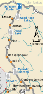
 BC-Yukon Border Highway 37 at BC-Yukon Border, looking north. |  Good Hope Lake Highway 37 near Good Hope Lake, looking north. |  Dease Lake Highway 37 at Commercial Drive in Dease Lake, looking north on Highway 37. |  Meziadin Junction Highway 37 and Highway 37A at Meziadin Junction, looking north. | |||||
 Gitanyow - N Highway 37N about 2.5 km south of Gitanyow at Kitwancool Access Road, looking north. |  Gitanyow - S Highway 37N about 2.5 km south of Gitanyow at Kitwancool Access Road, looking south. |  Onion Lake Highway 37S at Onion Lake Cross Country Ski trails, looking north. |  Kitimat Highway 37 about 5 km north of Kitimat at Oolichan Avenue, looking north. | |||||