BC HighwayCams - Highway 1 (Fraser Valley)
Northern, Southern Interior and Vancouver Island images will update every 15 to 30 minutes; Lower Mainland images will update about every two to 15 minutes.
Please note all BC HwyCams use Pacific Time Zone (PT).
Attention motorists:
Spring weather can make highway conditions in B.C. unpredictable, particularly through high mountain passes. Please be prepared and be aware that winter tires and chains may still be needed.
We reserve the right to restrict travel at any time of the year depending on road conditions.
Click for more information
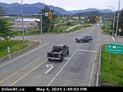 |
Prest Road - N
Highway 1 at Prest Road in Chilliwack, looking north. (elevation: 19 metres) |
||
Weather Forecast (from Environment Canada)All weather stations (current weather) for this region (map) |
|||
|
|||
 Hwy 1 at 176 Street - N Highway 1 at 176 Street overpass, looking north. |  Hwy 1 at 176 Street - W Highway 1 at 176 Street overpass, looking west. |  Hwy 1 at 176 Street - E Highway 1 at 176 Street overpass, looking east. |  Hwy 1 at 176 Street - S Highway 1 at 176 Street overpass, looking south. |
 Hwy 1 at 200 Street - N Highway 1 at 200 Street, looking north. |  Hwy 1 at 200 Street - W Highway 1 at 200 Street, looking west. |  Hwy 1 at 200 Street - E Highway 1 at 200 Street, looking east. |  Hwy 1 at 200 Street - S Highway 1 at 200 Street, looking south. |
 Hwy 1 at 216 Street - W Highway 1 at 216 Street overpass, looking west. |  Hwy 1 at 216 Street - E Highway 1 at 216 Street overpass, looking east. |  Hwy 1 at 232 Street - N Highway 1 westbound on-ramp from 232 Street, looking north. |  Hwy 1 at 232 Street - W Highway 1 at 232 Street overpass, looking west. |
 Hwy 1 at 232 Street - E Highway 1 at 232 Street Overpass, looking east. |  Hwy 1 at 232 Street - S Highway 1 eastbound on-ramp from 232 Street, looking south. |  Hwy 1 at 264 Street - N Highway 1 off-ramp to 264 Street, looking north. |  Hwy 1 at 264 Street - W Highway 1 at 264 Street, looking west. |
 Hwy 1 at 264 Street - E Highway 1 at 264 Street, looking east. |  Hwy 1 at 264 Street - S Highway 1 on-ramp from 264 Street, looking south. | Image Unavailable. Bradner Road Highway 1 near Bradner Road, looking east. | Image Unavailable. Bradner Road - W Highway 1 near Bradner Road, looking west. |
Image Unavailable. Bradner Road - E Highway 1 eastbound near Bradner Road, looking east. |  Mount Lehman - N Highway 1 at Mount Lehman Road, looking north. |  Mount Lehman - W Highway 1 at Mount Lehman Road, looking west. |  Mount Lehman - E Highway 1 at Mount Lehman Road, looking east. |
 Mount Lehman - S Highway 1 at Mount Lehman Road, looking south. |  Clearbrook - N Highway 1 at Clearbrook Road, looking north. |  Clearbrook - W Highway 1 at Clearbrook Road, looking west. |  Clearbrook - E Highway 1 at Clearbrook Road, looking east. |
 Clearbrook - S Highway 1 at Clearbrook Road, looking south. |  McCallum Road - W Highway 1 at McCallum Road overpass, looking west. |  McCallum Road - E Highway 1 at McCallum Road overpass, looking east. |  McCallum Road Roundabout Northbound Highway 1 at McCallum Road roundabout, looking north. |
 McCallum Road Roundabout Southbound Highway 1 at McCallum Road roundabout, looking south. |  Sumas Way - N Highway 1 at Highway 11 (Sumas Way) interchange in Abbotsford, looking north. |  Sumas Way - W Highway 1 at Highway 11 (Sumas Way) interchange in Abbotsford, looking west. |  Sumas Way - E Highway 1 at Highway 11 (Sumas Way) interchange in Abbotsford, looking east. |
 Sumas Way - S Highway 1 at Highway 11 (Sumas Way) interchange in Abbotsford, looking south. |  Cole Road - W Highway 1 at Cole Road Rest Area, looking west. |  Cole Road - E Highway 1 at Cole Road Rest Area, looking east. |  Vedder Canal Bridge - W Highway 1 at the Vedder Canal Bridge, looking westbound. |
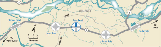
 Vedder Canal Bridge - E Highway 1 at Vedder Canal Bridge, looking eastbound. |  Evans Road - N Highway 1 at Evans Road overpass near Chilliwack, looking north. |  Evans Road - W Highway 1 at Evans Road overpass near Chilliwack, looking west. |  Evans Road - E Highway 1 at Evans Road overpass near Chilliwack, looking east. |
 Evans Road - S Highway 1 at Evans Road overpass near Chilliwack, looking south. |  Prest Road - N Highway 1 at Prest Road in Chilliwack, looking north. |  Prest Road - W Highway 1 at Prest Road in Chilliwack, looking west. |  Prest Road - E Highway 1 at Prest Road in Chilliwack, looking east. |
 Prest Road - S Highway 1 at Prest Road in Chilliwack, looking south. |  Annis Road - N Highway 1 at Annis Road overpass, looking north. |  Annis Road - W Highway 1 at Annis Road overpass, looking west. |  Annis Road - E Highway 1 at Annis Road overpass, looking east. |
 Annis Road - S Highway 1 at Annis Road overpass, looking south. |  Bridal Falls - W Highway 1 near Bridal Falls, looking west. |  Bridal Falls - E Highway 1 near Bridal Falls, looking east. |  Herrling Island - W Highway 1 near Herrling Island, looking west. |
 Herrling Island - E Highway 1 near Herrling Island, looking east. |  Herrling Island Overpass - N Highway 1 at Herrling Island overpass, looking north. |  Herrling Island Overpass - W Highway 1 westbound at Herrling Island overpass, looking west. |  Herrling Island Overpass - E Highway 1 westbound at Herrling Island overpass, looking east. |
 Herrling Island Overpass - S Highway 1 at Herrling Island overpass, looking south. |  Hunter Creek Highway 1 at Hunter Creek, looking east. |
||