BC HighwayCams - Highway 99 (Peace Arch Border Crossing)
Northern, Southern Interior and Vancouver Island images will update every 15 to 30 minutes; Lower Mainland images will update about every two to 15 minutes.
Please note all BC HwyCams use Pacific Time Zone (PT).
Attention motorists:
Spring weather can make highway conditions in B.C. unpredictable, particularly through high mountain passes. Please be prepared and be aware that winter tires and chains may still be needed.
We reserve the right to restrict travel at any time of the year depending on road conditions.
Click for more information
 |
|
|||||||
|
||||||||
Weather Forecast (from Environment Canada)All weather stations (current weather) for this region (map) |
||||||||
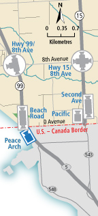
 Hwy 99 at 8 Avenue - N Highway 99 at 8 Avenue in White Rock, looking north. |  Hwy 99 at 8 Avenue - W Highway 99 at 8 Avenue in White Rock, looking west at southbound ramp from 8 Avenue. |  Hwy 99 at 8 Avenue - S Highway 99 at 8 Avenue in White Rock, looking south. |  Beach Road - N Highway 99 at Canada/USA border, looking north. | |||||
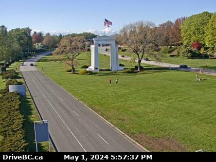
 Beach Road - S Highway 99 near Canada/USA border, looking south. |  Peace Arch Highway 99 at Peace Arch border crossing, looking north. |
|||||||