BC HighwayCams - Highway 97C
Northern, Southern Interior and Vancouver Island images will update every 15 to 30 minutes; Lower Mainland images will update about every two to 15 minutes.
Please note all BC HwyCams use Pacific Time Zone (PT).
Attention motorists:
Fall weather can make highway conditions in B.C. unpredictable, particularly through high mountain passes. Winter tires or chains are required on most routes in British Columbia from October 1 to April 30.

Click for more information
NEW!
 |
|
|||||||
|
||||||||
Weather Forecast (from Environment Canada)All weather stations (current weather) for this region (map) |
||||||||
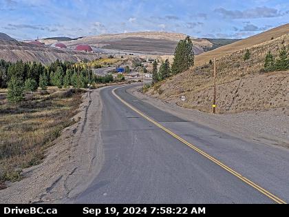
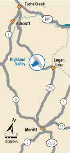
 Highland Valley Road - N Highway 97C at Highland Valley Road between Merritt and Ashcroft, looking north. |  Highland Valley Road - W Highway 97C at Highland Valley Road between Merritt and Ashcroft, looking west. |  Highland Valley Road - S Highway 97C at Highland Valley Road between Merritt and Ashcroft, looking south. |  Aspen Grove - N Highway 97C (Okanagan Connector) at Highway 5A junction near Aspen Grove, looking north. | |||||
 Aspen Grove - S Highway 97C (Okanagan Connector) at Highway 5A junction near Aspen Grove, looking south. |  Pothole Lake - W Highway 97C (Okanagan Connector) about 7 km east of Aspen Grove near Pothole Lake, looking west. |  Pothole Lake - E Highway 97C (Okanagan Connector) about 7 km east of Aspen Grove near Pothole Lake, looking east. |  Elkhart - W Highway 97C (Okanagan Connector) about 25 km east of Highway 5A and Highway 97C junction, looking west. | |||||
 Elkhart - E Highway 97C (Okanagan Connector) about 25 km east of Highway 5A and Highway 97C junction, looking east. |  Pennask Summit Highway 97C (Okanagan Connector) about 74 km west of Kelowna, looking east. |  Brenda Mine - W Highway 97C (Okanagan Connector), about 22 km west of Highway 97 and Highway 97C junction, looking west. |  Brenda Mine - E Highway 97C (Okanagan Connector) about 22 km west of Highway 97 and Highway 97C Junction, looking east. | |||||