BC HighwayCams - Highway 6
Northern, Southern Interior and Vancouver Island images will update every 15 to 30 minutes; Lower Mainland images will update about every two to 15 minutes.
Please note all BC HwyCams use Pacific Time Zone (PT).
Attention motorists:
Spring weather can make highway conditions in B.C. unpredictable, particularly through high mountain passes. Please be prepared and be aware that winter tires and chains may still be needed.
 |
|
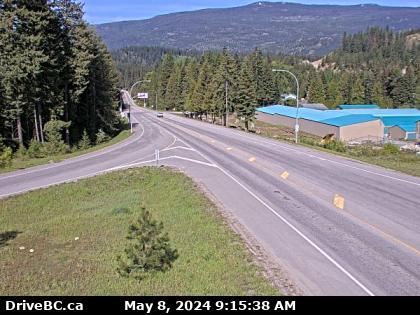
| Playmor Junction - W
Hwy 6 at Hwy 3A in Playmor Junction, looking west. (elevation: 508 metres) |
|
|
|
|
Weather Forecast (from Environment Canada) |
 |
|
Shuswap Hill - W
Hwy 6, Shuswap Hill west of Cherryville, looking west. | Shuswap Hill - E
Hwy 6, Shuswap Hill west of Cherryville, looking east. | Monashee Pass
Hwy 6, 83 km east of Vernon, looking westbound. | Needles Ferry Bend End
Hwy 6 at Needles Ferry Landing, looking west away from ferry landing towards Needles Rd N. |
Needles Ferry Bend Middle
Hwy 6 at Needles Ferry Landing, looking east to ferry landing. | Needles Ferry Rest Area
Hwy 6 at Needles Ferry Landing, looking east towards front of line up near the rest area. | Needles Ferry Front - W
Hwy 6 at front of Needles Ferry Landing line up, looking west. | Needles Ferry Front - E
Hwy 6 at front Needles Ferry Landing line up, looking east. |
Fauquier Ferry - W
Hwy 6 at Fauquier Ferry Landing, looking west. | Fauquier Ferry - E
Hwy 6 at Fauquier Ferry Landing, looking east. | Fauquier at Starlite Rd - W
Hwy 6 at Starlite Road, looking west towards Fauquier. | Fauquier at Starlite Rd - E
Hwy 6 at Starlite Road, looking east towards Burton. |
Burton Main Road
Hwy 6, in Burton at Burton Main Rd, about 22 km north of Fauquier, looking south. | Arrow Park Ferry North Terminal
Hwy 6 at South Arrow Park Ferry Terminal, 22km south of Nakusp at junction of Upper and Lower Arrow Lakes, looking at north landing. | Arrow Park Ferry South Terminal - N
Hwy 6 at South Arrow Park Ferry Terminal, 22km south of Nakusp at junction of Upper and Lower Arrow Lakes, looking north. | Arrow Park Ferry South Terminal - S
Hwy 6 at South Arrow Park Ferry Terminal, 22km south of Nakusp at junction of Upper and Lower Arrow Lakes, looking south on Arrow Park Road. |
Nakusp
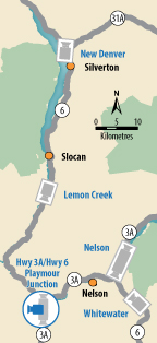
Junction of Hwy 6 and Hwy 23 in Nakusp, looking south along Hwy 6. | New Denver
Hwy 6 at Hwy 31A in New Denver, looking north. | Lemon Creek
Hwy 6 at Kennedy Rd/Lemon Creek Rd, looking south near Lemon Creek, about 8km south of Slocan. | Playmor Junction - N
Hwy 6 at Hwy 3A in Playmor Junction, looking north. |
Playmor Junction - W
Hwy 6 at Hwy 3A in Playmor Junction, looking west. | Playmor Junction - S
Hwy 6 at Hwy 3A in Playmor Junction, looking south. | Nelson - N
Hwy 6 near Hwy 3A and Rosemont/Uphill interchange, looking north. | Nelson - S
Hwy 6 near Hwy 3A and Rosemont/Uphill interchange, looking south. |
Whitewater
Hwy 6, at Whitewater Ski Hill Rd about 12.5 km south of Nelson, looking north. | Ymir
Hwy 6, in Ymir at First Ave, looking south. |