BC HighwayCams - Highway 3
Northern, Southern Interior and Vancouver Island images will update every 15 to 30 minutes; Lower Mainland images will update about every two to 15 minutes.
Please note all BC HwyCams use Pacific Time Zone (PT).
Attention motorists:
Spring weather can make highway conditions in B.C. unpredictable, particularly through high mountain passes. Please be prepared and be aware that winter tires and chains may still be needed.
 |
|
|||||||
|
||||||||
 Hwy 3 at Hwy3/5 Jct Highway 3 at 3/5 junction looking east. |  Hope Slide Hwy 3 at the Hope Slide pullout, looking east. |  Allison Pass - W Hwy 3 at Allison Pass, 10 km west of Manning Park resort area, looking west. |  Allison Pass - E Hwy 3 at Allison Pass, 10 km west of Manning Park resort area, looking east. | |||||
 Similkameen Falls - W Hwy 3 near Similkameen Falls, about 6 kms east of Eastgate, looking west. |  Similkameen Falls - E Hwy 3 near Similkameen Falls, about 6 kms east of Eastgate, looking east. |  Sunday Summit Hwy 3, approximately 32 km south of Princeton, looking north. |  Princeton Hwy 3 at Frontage Rd on the west side of Princeton, looking south. | |||||
 Bromley Rock - W Hwy 3, about 1.4 km east of Bromley Rock Provincial Park, looking west. |  Bromley Rock - E Hwy 3, about 1.4 km east of Bromley Rock Provincial Park, looking east. |  Keremeos - W Hwy 3 at Keremeos Bypass Rd, looking west. |  Keremeos - E Hwy 3 at Keremeos Bypass Rd, looking east. | |||||
 Mt Kobau - W Hwy 3, next to Conifryd Lake, looking west. |  Mt Kobau - E Hwy 3 next to Conifryd Lake, looking east. |  Anarchist Hwy 3, 9 km west of the Anarchist Summit, east of Osoyoos, looking east. |  Rock Creek Hwy 3 at Hwy 33 junction in Rock Creek, looking north-west. | |||||
 Midway - W Hwy 3 in Midway, at Florence St, looking west. |  Midway - E Hwy 3 in Midway, at Florence St, looking east. |  Midway - S Hwy 3 in Midway, at Florence St, looking south. |  Eholt Summit Hwy 3 at Wilgress Rest Area near Eholt Summit, about 16km northeast of Greenwood, looking westbound. | |||||
 Christina Lake Hwy 3 at East Lake Drive on east side of Christina Lake, looking northwest. | Camera out of operation Paulson Summit Hwy 3, about 3 km east of Paulson Summit, looking west. |  Castlegar Hwy 3 at 14th Ave. in Castlegar, looking east. |  Bombi Pass Hwy 3, at the Bombi Summit, approximately 22 km south-east of Castlegar, looking west. | |||||
Image Temporarily Unavailable. Meadows Jct Hwy 3 at Hwy 3B junction looking westbound. |  Salmo Hwy 3 at Hwy 6, looking west on Hwy 3. |  Kootenay Pass Hwy 3, Salmo Creston Highway Summit, looking east. |  Creston Hwy 3 and Hwy 3A junction at Creston, looking southeast. | |||||
 Leadville Rd Hwy 3, in Kitchener about 18 km east of Creston, looking east. |  Goatfell - W Hwy 3, near Goatfell, about 9 km northwest of Yahk, looking west. |  Goatfell - E Hwy 3, near Goatfell, about 9 km northwest of Yahk, looking east. |  Yahk Hwy 3 at Hwy 95, Yahk Weigh Scale, looking north-east. | |||||
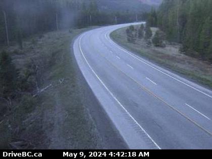
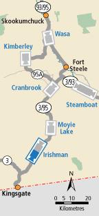
 Irishman - N Hwy 3, about 21 km southwest of Moyie, looking north. |  Irishman - S Hwy 3, about 21 km southwest of Moyie, looking south. |  Moyie Lake Hwy 3, near the south end of Moyie Lake, looking north. |  Cranbrook Hwy 3/95 at 9th Ave. in Cranbrook, looking northeast. | |||||
 Steamboat- NW Hwy 3/93 near Ha Ha Creek Road, looking northwest. |  Steamboat - SE Hwy 3/93 near Ha Ha Creek Road, looking southeast. |  Elko - W Hwy 3, about 1 km west of Elko at Hwy 93 junction, looking west. |  Elko - E Hwy 3, about 1 km west of Elko at Hwy 93 junction, looking east. | |||||
 Elko - S Hwy 3, about 1 km west of Elko at Hwy 93 junction, looking south. |  Morrissey Hwy 3, about 10km south of Fernie at Morrissey Jct, looking north. |  Hosmer Hwy 3, in Hosmer, about 12km north of Fernie, looking north. |  Sparwood Hwy 3 at Sparwood weigh scale, about 2 km west of the Alberta border, looking south-east. | |||||