BC HighwayCams - Highway 17
Northern, Southern Interior and Vancouver Island images will update every 15 to 30 minutes; Lower Mainland images will update about every two to 15 minutes.
Please note all BC HwyCams use Pacific Time Zone (PT).
 Attention motorists:
Winter tires or chains are required on most routes in British Columbia from October 1 to April 30. For select highways not located through mountain passes and/or high snowfall areas, tire and chain requirements end March 31. These routes are marked with regulatory signs posted on highways throughout the province. We reserve the right to restrict travel at any time of the year depending on road conditions.
Click for more information
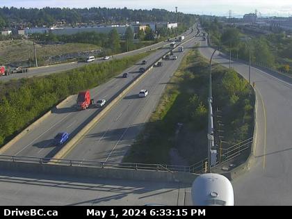 |
Tannery Rd Overpass - W
Hwy 17 (South Fraser Perimeter Rd) at Tannery Rd Overpass in Surrey, looking west. (elevation: 5 metres)
|
Weather Forecast (from Environment Canada)
|
|
 |
|
Deltaport Way - N
Hwy 17 (South Fraser Perimeter Rd) at Deltaport Way in South Delta, looking north. | Deltaport Way - E
Hwy 17 (South Fraser Perimeter Rd) at Deltaport Way in South Delta, looking east. | Deltaport Way - S
Hwy 17 (South Fraser Perimeter Rd) at Deltaport Way in South Delta, looking south. | Salish Sea Dr - N
Hwy 17 at Salish Sea Drive (48th Street), looking north. |
Salish Sea Dr - W
Hwy 17 at Salish Sea Drive (48th Street), looking west. | Salish Sea Dr - E
Hwy 17 at Salish Sea Drive (48th Street), looking east. | Hwy 17 at 52 St - N
Hwy 17 at 52nd Street, looking north. | Hwy 17 at 52 St - W
Hwy 17 at 52nd Street, looking west. |
Hwy 17 at 52 St - E
Hwy 17 at 52nd Street, looking east. | Hwy 17 at 52 St - S
Hwy 17 at 52nd Street, looking south. | Hwy 17 at 56 St - N
Hwy 17 at 56th St., looking north. | Hwy 17 at 56 St - W
Hwy 17 at 56th St., looking west. |
Hwy 17 at 56 St - E
Hwy 17 at 56th St., looking east. | Hwy 17 at 56 St - S
Hwy 17 at 56th St., looking south. | Hwy 17 at 80 St - N
Hwy 17 (South Fraser Perimeter Rd) at 80th Street, looking north. | Hwy 17 at 80 St - W
Hwy 17 (South Fraser Perimeter Rd) at 80th Street, looking west. |
Hwy 17 at 80 St - E
Hwy 17 (South Fraser Perimeter Rd) at 80th Street, looking east. | Hwy 17 at Hwy 91 Connector - N
Hwy 17 (South Fraser Perimeter Rd), at Hwy 91 Connector, looking north. | Hwy 17 at Hwy 91 Connector - W
Hwy 17 (South Fraser Perimeter Rd), at Hwy 91 Connector, looking west. | Hwy 17 at Hwy 91 Connector - E
Hwy 17 (South Fraser Perimeter Rd), at Hwy 91 Connector, looking east. |
Tannery Rd Overpass - N
Hwy 17 (South Fraser Perimeter Rd) at Tannery Rd Overpass in Surrey, looking north. | Tannery Rd Overpass - W
Hwy 17 (South Fraser Perimeter Rd) at Tannery Rd Overpass in Surrey, looking west. | Tannery Rd Overpass - E
Hwy 17 (South Fraser Perimeter Rd) at Tannery Rd Overpass in Surrey, looking east. | Tannery Rd Overpass - S
Hwy 17 (South Fraser Perimeter Rd) at Tannery Rd Overpass in Surrey, looking south. |
Bridgeview Dr - W
Hwy 17 (South Fraser Perimeter Rd) at Bridgeview Dr, looking west. | Bridgeview Dr - E
Hwy 17 (South Fraser Perimeter Rd) at Bridgeview Dr, looking east. | Bridgeview Dr - S
Hwy 17 (South Fraser Perimeter Rd) at Bridgeview Dr, looking south. | 104 Ave at Hwy 17 westbound
104th Avenue and Hwy 17, looking westbound. |
Hwy 17 at 104 Ave eastbound
Hwy 17 at 104th Avenue eastbound along Hwy 17. | 104 Ave at Hwy 17 eastbound
104th Avenue at Hwy 17 looking east. | Hwy 17 at 104 Ave southbound
Hwy 17 at 104th Avenue looking southbound. |